
OUR ISLAND
By Mary Etheridge
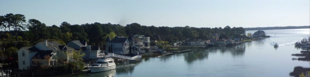
Broad Bay Island is located in the Great Neck area of Virginia Beach, VA near the Lynnhaven Inlet and the mouth of the Chesapeake Bay.
It is an Island at the western end of Broad Bay and is approximately 2 miles long and ¼ mile wide. The Island was originally connected to the Great Neck peninsula by a marsh. The north side of the Island is bordered by Long Creek, connecting Broad Bay to the Lynnhaven Inlet and the Chesapeake Bay.
The Chesapeake Indians once occupied this area. Their principal village, Chesepioc, was located at what is now Great Neck. Archaeologists have discovered evidence of four distinct civilizations at that site, the earliest dating back approximately 11,500 years.
The Lesner Bridge over the :Lynnhaven Inlet was built in the late 1920’s as a single lift two-lane bridge and was replaced by the original two-lane high-level bridge in 1958. Before the Lesner Bridge, there was a single lift trestle built in 1902 for railroad service to Cape Henry. By the 1920’s the trestle was planked so cars could cross the inlet. The trestle was torn down in the 1950’s. Both the bridge and the trestle had to open to let boats into and out of the Lynnhaven Inlet.
There was no high-rise bridge for access to our Island in those days. There were two bridges, both wooden and ground level; one crossed over what had been a mosquito-control drainage ditch dug through the marsh. The original ditch was about 6 ft wide and 1 ft deep. Prior to this ditch, the area was marsh with a man-made causeway to get to the Long Creek Bridge.
When the mosquito ditch was dug, a bridge was established with about a 12 ft clearance and it was called by some the “Beach Canal”. though some papers show it as “Long Creek Canal”. During the early 1950’s, the Cavalier Yacht Cub and the Davis Island Boat Club dredged the ditch several times until it was about 20 ft wide and 4 ft deep, so that boats did not have to navigate Long Creek, which was very shallow and crooked. In 1960, our current bridge was built.
The original Long Creek Bridge was a hand-operated drawbridge operated by Mr. W. Rowe, Sr., one of our earliest residents. It was the only access into Broad and Linkhorn Bays unless the vessel could pass under the Beach Canal Bridge. The bridge over Long Creek had a restaurant attached to it called the “Seven Seas”, which was later moved to the west side of the Lesner Bridge.
It is believed that the island was at one time called “Davis Island”; a boat club occupied the western tip, and provided a boat ramp for about 100 members. It had been fenced off, had electricity, and a picnic area, and provided metal ramps for launching boats. Many desired the water access since the Long Creek Bridge only had 5 ft clearance, or had to be opened for passage into and out of Broad Bay. When our present bridge was proposed, the Civic League objected to an access to the west end of the island by a private boat club and the club ceased to operate.
In 1943, Alonzo Cherry, an Engineer was requested by Clyde Absalom to plat an area to be called Broad Bay Point in what was Great Neck, Lynnhaven Magisterial District, Princess Ann County, Virginia, with 25 lots.
What is now Hackberry Rd. on the north side of Broad Bay Road, opposite Canal Road, was named “Holly Rd”. It is assumed that the name was changed in 1963 when the city of Virginia Beach merged with Princess Anne County because there was already a “Holly Road” in Virginia Beach.
The postal address for Island residents in the 1950’s was Route 1, London Bridge, VA. The road onto the island was named Broad Bay Road. In the early days the road was mainly sand and clay, and prior to 1949 ended at the end of Broad Bay Point; but as construction of Broad Bay Colony began, the road gradually was topped with rocks and the asphalt. There were several residences, along with Marshall’s Seafood business and motel with 8 – 10 units, located in the vicinity of what is now Bay Island Quay. Broad Bay Point started just after the current fifth house on the right after entering the Island. There was a brick entryway marker on each side of the road. The marker on the right is still there, but the one on the left was destroyed when homes were built on the left hand side of the road. road Bay Point ended at the big curve and pine tree just past Long Creek Rd, In 1949, the plat was amended to add lots #26 through #46, these latest lots being all the lots on
the south side of Broad Bay Road in Broad Bay Point and to include Canal Road. It is believed that Mr. Absalom dredged the small waterway (wide enough for a skiff) to make these lots. This canal of navigable water was about 20 feet wide. The amended plat indicates that Barron F. Black owned the property east of Broad Bay Point. That property was platted as Broad Bay Colony in the early 1950’s. Broad Bay Road ended at Lone Pine Road which is now the entrance into Bay Island.
In 1954 there were only two houses on Canal Road, which ended just before the Beach Canal. A navigable canal ran past those lots and those on the south side of Broad Bay Road and the Beach Canal. Around 1958 the wetland marsh between Broad Bay Rd and the Beach Canal was dredged and filled in, and houses built on a continuation of Canal Road which extended to an area parallel the beginning of Broad Bay Point. An aerial view of that area in 1962 shows 5 houses.
Our current entrance bridge was completed in 1960, along with the dredging and widening of the beach canal, and a stoplight was placed on top of it for traffic. In connection with the widening of Great Neck Road to a dual lane highway, a new high-rise bridge was constructed to cross our Island for a more direct connection to London Bridge from Shore Drive. Two houses were relocated; they were at the foot of our access onto the Island on the Long Creek side. One that was moved was floated up to North Carolina. The other was moved to what is now 2814 Broad Bay Road. The high-rise bridge over the Island and North Great Neck road was completed in 1988. “Great Neck Road” was renamed “West Great Neck Rd.” and the dual highway was given the name, “North Great Neck Road”. Prior to that time all traffic to London Bridge or Hilltop had to pass over “the bridge with the light on top.”
There were no streetlights or fire hydrants until the late 1950’s. High water has always been a problem in the area. In 1958 there was a high water and in 1962 was the Ash Wednesday Storm and many since then., City water was brought onto the Island around 1968 and sewage in 1989. The finger lots at the entrance (5 houses) on the south side of Broad Bay Road could not be built on until sewage to the Island was installed. This land was originally owned by J. Abdington.
Bay Island was originally topographically like Seashore State Park “Currently named First Landing State park”.. A M. Whitehurst began development in 1959, and lots sold for $13,500. The first Bay Island house was built on Windward Shore Drive. A 1962 aerial map shows about 33 houses on Bay Island. Bay Island had almost as many canals as streets, with most homes having backyard waterway access. As reported in the 1991 Real Estate Weekly “Across the water from Seashore state Park, and reaching in Broad Bay like the tentacles of a giant squid, is Bay Island, Virginia Beaches’ answer to Venice. Bay Island is canals; serene, secluded canals that invite you to glide into the neighborhood straight up to your own back door.”